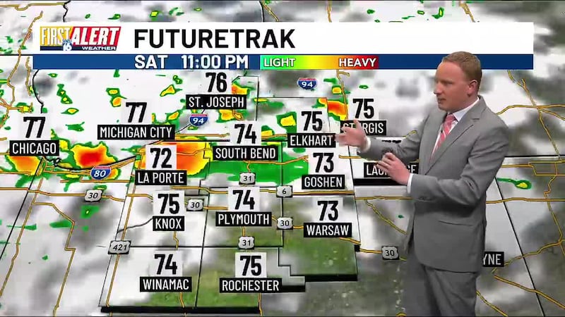
First Alert Weather: Rain and lightning Saturday night to Sunday morning
Cleanup efforts may be hampered by gusty winds Saturday and Sunday
SOUTH BEND, Ind. — If you’re working to clear up storm damage from Wednesday and Thursday, you’ll want to secure loose items this weekend. Gusty winds will remain a concern through Sunday afternoon as a cold front moves into the region.
Saturday: Windy with Afternoon Gusts
Saturday will bring persistent winds with gusts reaching up to 30 mph during afternoon hours. While conditions will start partly cloudy, a cold front moving in Saturday night will trigger a few thundershowers at times. Severe weather is not expected locally.
High temperatures will reach the mid-80s Saturday, with it feeling humid outside ahead of a cold front Sunday.
Sunday: Chilly Afternoon, Showers Possible
The cold front will continue pushing through Sunday morning, bringing a few thundershowers at times. By Sunday afternoon, temperatures will struggle to reach 70 degrees, noticeably chilly for mid-June. Winds will remain gusty throughout the day. RED flags will be flying at Lake Michigan due to a northwest wind gusting up to 30 mph. Stay out of the water as the rip current risk will be high and off the piers!
Anyone still working on cleanup should plan accordingly, as the wind and cooler temperatures will persist through the afternoon.
Looking Ahead: Typical June Weather Returns
Conditions will settle down early next week, with highs returning to the comfortable low-to-mid 70s across Michiana. However, don’t put away the umbrella just yet.
A First Alert storm chance will arrive next Tuesday and Wednesday as our next weather system moves in. Father’s Day weekend could bring some unsettled weather across the region, so stay with us for updates as we track these systems.
Copyright 2025 WNDU. All rights reserved.